marble
#include <GeoDataDocument_p.h>

Public Member Functions | |
| GeoDataDocumentPrivate () | |
| virtual GeoDataFeaturePrivate * | copy () |
| virtual EnumFeatureId | featureId () const |
| virtual const char * | nodeType () const |
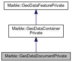
 Public Member Functions inherited from Marble::GeoDataContainerPrivate Public Member Functions inherited from Marble::GeoDataContainerPrivate | |
| GeoDataContainerPrivate () | |
| ~GeoDataContainerPrivate () | |
| GeoDataContainerPrivate & | operator= (const GeoDataContainerPrivate &other) |
 Public Member Functions inherited from Marble::GeoDataFeaturePrivate Public Member Functions inherited from Marble::GeoDataFeaturePrivate | |
| GeoDataFeaturePrivate () | |
| GeoDataFeaturePrivate (const GeoDataFeaturePrivate &other) | |
| virtual | ~GeoDataFeaturePrivate () |
| GeoDataFeaturePrivate & | operator= (const GeoDataFeaturePrivate &other) |
Public Attributes | |
| QString | m_baseUri |
| DocumentRole | m_documentRole |
| QString | m_filename |
| GeoDataNetworkLinkControl | m_networkLinkControl |
| QString | m_property |
| QMap< QString, GeoDataSchema > | m_schemaHash |
| QMap< QString, GeoDataStyle > | m_styleHash |
| QMap< QString, GeoDataStyleMap > | m_styleMapHash |
 Public Attributes inherited from Marble::GeoDataContainerPrivate Public Attributes inherited from Marble::GeoDataContainerPrivate | |
| QVector< GeoDataFeature * > | m_vector |
 Public Attributes inherited from Marble::GeoDataFeaturePrivate Public Attributes inherited from Marble::GeoDataFeaturePrivate | |
| GeoDataAbstractView * | m_abstractView |
| QString | m_address |
| QString | m_description |
| bool | m_descriptionCDATA |
| GeoDataExtendedData | m_extendedData |
| QString | m_name |
| QString | m_phoneNumber |
| qint64 | m_popularity |
| GeoDataRegion | m_region |
| QString | m_role |
| GeoDataSnippet | m_snippet |
| const GeoDataStyle * | m_style |
| const GeoDataStyleMap * | m_styleMap |
| QString | m_styleUrl |
| GeoDataTimeSpan | m_timeSpan |
| GeoDataTimeStamp | m_timeStamp |
| bool | m_visible |
| GeoDataFeature::GeoDataVisualCategory | m_visualCategory |
| int | m_zoomLevel |
| QAtomicInt | ref |
Additional Inherited Members | |
 Static Public Member Functions inherited from Marble::GeoDataFeaturePrivate Static Public Member Functions inherited from Marble::GeoDataFeaturePrivate | |
| static GeoDataStyle * | createHighwayStyle (const QString &bitmap, const QColor &color, qreal width=1, qreal realWidth=0.0, Qt::PenStyle penStyle=Qt::SolidLine, Qt::PenCapStyle capStyle=Qt::RoundCap) |
| static GeoDataStyle * | createOsmPOIStyle (const QFont &font, const QString &bitmap, const QColor &color=QColor(0xBE, 0xAD, 0xAD), const QColor &outline=QColor(0xBE, 0xAD, 0xAD).darker()) |
| static GeoDataStyle * | createStyle (qreal width, qreal realWidth, const QColor &color, const QColor &outlineColor, bool fill, bool outline, Qt::BrushStyle brushStyle, Qt::PenStyle penStyle, Qt::PenCapStyle capStyle, bool lineBackground, const QVector< qreal > &dashPattern=QVector< qreal >()) |
| static GeoDataStyle * | createWayStyle (const QColor &color, const QColor &outlineColor, bool fill=true, bool outline=true, Qt::BrushStyle brushStyle=Qt::SolidPattern) |
| static void | initializeDefaultStyles () |
| static void | initializeOsmVisualCategories () |
 Static Public Attributes inherited from Marble::GeoDataFeaturePrivate Static Public Attributes inherited from Marble::GeoDataFeaturePrivate | |
| static QFont | s_defaultFont = QFont("Sans Serif") |
| static QColor | s_defaultLabelColor = QColor( Qt::black ) |
| static GeoDataStyle * | s_defaultStyle [GeoDataFeature::LastIndex] |
| static bool | s_defaultStyleInitialized = false |
| static QMap< QString, GeoDataFeature::GeoDataVisualCategory > | s_visualCategories |
Detailed Description
Definition at line 25 of file GeoDataDocument_p.h.
Constructor & Destructor Documentation
|
inline |
Definition at line 28 of file GeoDataDocument_p.h.
Member Function Documentation
|
inlinevirtual |
Reimplemented from Marble::GeoDataContainerPrivate.
Definition at line 33 of file GeoDataDocument_p.h.
|
inlinevirtual |
Reimplemented from Marble::GeoDataContainerPrivate.
Definition at line 45 of file GeoDataDocument_p.h.
|
inlinevirtual |
Reimplemented from Marble::GeoDataContainerPrivate.
Definition at line 40 of file GeoDataDocument_p.h.
Member Data Documentation
| QString Marble::GeoDataDocumentPrivate::m_baseUri |
Definition at line 54 of file GeoDataDocument_p.h.
| DocumentRole Marble::GeoDataDocumentPrivate::m_documentRole |
Definition at line 57 of file GeoDataDocument_p.h.
| QString Marble::GeoDataDocumentPrivate::m_filename |
Definition at line 53 of file GeoDataDocument_p.h.
| GeoDataNetworkLinkControl Marble::GeoDataDocumentPrivate::m_networkLinkControl |
Definition at line 55 of file GeoDataDocument_p.h.
| QString Marble::GeoDataDocumentPrivate::m_property |
Definition at line 56 of file GeoDataDocument_p.h.
| QMap<QString, GeoDataSchema> Marble::GeoDataDocumentPrivate::m_schemaHash |
Definition at line 52 of file GeoDataDocument_p.h.
| QMap<QString, GeoDataStyle> Marble::GeoDataDocumentPrivate::m_styleHash |
Definition at line 50 of file GeoDataDocument_p.h.
| QMap<QString, GeoDataStyleMap> Marble::GeoDataDocumentPrivate::m_styleMapHash |
Definition at line 51 of file GeoDataDocument_p.h.
The documentation for this class was generated from the following file:
Documentation copyright © 1996-2020 The KDE developers.
Generated on Mon Jun 22 2020 13:13:44 by doxygen 1.8.7 written by Dimitri van Heesch, © 1997-2006
KDE's Doxygen guidelines are available online.
 KDE API Reference