• Skip to content
  • Skip to link menu
KDE API Reference
  • KDE API Reference
  • kdeedu API Reference
  • KDE Home
  • Contact Us
 

marble

  • Marble
  • GeoDataPhotoOverlay
Public Types | Public Member Functions | List of all members
Marble::GeoDataPhotoOverlay Class Reference

#include <GeoDataPhotoOverlay.h>

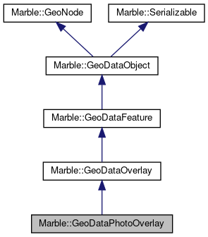
Inheritance diagram for Marble::GeoDataPhotoOverlay:
Inheritance graph
[legend]

Public Types

enum  Shape { Rectangle, Cylinder, Sphere }
 
- Public Types inherited from Marble::GeoDataFeature
enum  GeoDataVisualCategory {
  None, Default, Unknown, SmallCity,
  SmallCountyCapital, SmallStateCapital, SmallNationCapital, MediumCity,
  MediumCountyCapital, MediumStateCapital, MediumNationCapital, BigCity,
  BigCountyCapital, BigStateCapital, BigNationCapital, LargeCity,
  LargeCountyCapital, LargeStateCapital, LargeNationCapital, Nation,
  Mountain, Volcano, Mons, Valley,
  Continent, Ocean, OtherTerrain, Crater,
  Mare, GeographicPole, MagneticPole, ShipWreck,
  AirPort, Observatory, Wikipedia, OsmSite,
  Coordinate, MannedLandingSite, RoboticRover, UnmannedSoftLandingSite,
  UnmannedHardLandingSite, Folder, Bookmark, NaturalWater,
  NaturalWood, HighwaySteps, HighwayUnknown, HighwayPath,
  HighwayTrack, HighwayPedestrian, HighwayService, HighwayRoad,
  HighwayTertiaryLink, HighwayTertiary, HighwaySecondaryLink, HighwaySecondary,
  HighwayPrimaryLink, HighwayPrimary, HighwayTrunkLink, HighwayTrunk,
  HighwayMotorwayLink, HighwayMotorway, Building, AccomodationCamping,
  AccomodationHostel, AccomodationHotel, AccomodationMotel, AccomodationYouthHostel,
  AmenityLibrary, EducationCollege, EducationSchool, EducationUniversity,
  FoodBar, FoodBiergarten, FoodCafe, FoodFastFood,
  FoodPub, FoodRestaurant, HealthDoctors, HealthHospital,
  HealthPharmacy, MoneyAtm, MoneyBank, ShoppingBeverages,
  ShoppingHifi, ShoppingSupermarket, TouristAttraction, TouristCastle,
  TouristCinema, TouristMonument, TouristMuseum, TouristRuin,
  TouristTheatre, TouristThemePark, TouristViewPoint, TouristZoo,
  TransportAerodrome, TransportAirportTerminal, TransportBusStation, TransportBusStop,
  TransportCarShare, TransportFuel, TransportParking, TransportRentalBicycle,
  TransportRentalCar, TransportTaxiRank, TransportTrainStation, TransportTramStop,
  ReligionPlaceOfWorship, ReligionBahai, ReligionBuddhist, ReligionChristian,
  ReligionHindu, ReligionJain, ReligionJewish, ReligionShinto,
  ReligionSikh, LeisurePark, LanduseAllotments, LanduseBasin,
  LanduseCemetery, LanduseCommercial, LanduseConstruction, LanduseFarmland,
  LanduseFarmyard, LanduseGarages, LanduseGrass, LanduseIndustrial,
  LanduseLandfill, LanduseMeadow, LanduseMilitary, LanduseQuarry,
  LanduseRailway, LanduseReservoir, LanduseResidential, LanduseRetail,
  RailwayRail, RailwayTram, RailwayLightRail, RailwayAbandoned,
  RailwaySubway, RailwayPreserved, RailwayMiniature, RailwayConstruction,
  RailwayMonorail, RailwayFunicular, Satellite, LastIndex
}
 

Public Member Functions

 GeoDataPhotoOverlay ()
 
 GeoDataPhotoOverlay (const GeoDataPhotoOverlay &other)
 
 ~GeoDataPhotoOverlay ()
 
GeoDataImagePyramid & imagePyramid ()
 
const GeoDataImagePyramid & imagePyramid () const
 
virtual const char * nodeType () const
 
bool operator!= (const GeoDataPhotoOverlay &other) const
 
GeoDataPhotoOverlay & operator= (const GeoDataPhotoOverlay &other)
 
bool operator== (const GeoDataPhotoOverlay &other) const
 
GeoDataPoint & point ()
 
const GeoDataPoint & point () const
 
qreal rotation () const
 
void setImagePyramid (const GeoDataImagePyramid &imagePyramid)
 
void setPoint (const GeoDataPoint &point)
 
void setRotation (const qreal rotation)
 
void setShape (Shape shape)
 
void setViewVolume (const GeoDataViewVolume &viewVolume)
 
Shape shape () const
 
GeoDataViewVolume & viewVolume ()
 
const GeoDataViewVolume & viewVolume () const
 
- Public Member Functions inherited from Marble::GeoDataOverlay
 GeoDataOverlay ()
 
 GeoDataOverlay (const GeoDataOverlay &other)
 
 ~GeoDataOverlay ()
 
QString absoluteIconFile () const
 
QColor color () const
 
int drawOrder () const
 
QImage icon () const
 
QString iconFile () const
 
GeoDataOverlay & operator= (const GeoDataOverlay &other)
 
void setColor (const QColor &color)
 
void setDrawOrder (int order)
 
void setIcon (const QImage &icon)
 
void setIconFile (const QString &path)
 
- Public Member Functions inherited from Marble::GeoDataFeature
 GeoDataFeature ()
 
 GeoDataFeature (const QString &name)
 
 GeoDataFeature (const GeoDataFeature &other)
 
virtual ~GeoDataFeature ()
 
const GeoDataAbstractView * abstractView () const
 
GeoDataAbstractView * abstractView ()
 
QString address () const
 
const GeoDataStyle * customStyle () const
 
QString description () const
 
bool descriptionIsCDATA () const
 
virtual void detach ()
 
GeoDataExtendedData & extendedData () const
 
EnumFeatureId featureId () const
 
bool isGloballyVisible () const
 
bool isVisible () const
 
QString name () const
 
GeoDataFeature & operator= (const GeoDataFeature &other)
 
virtual void pack (QDataStream &stream) const
 
QString phoneNumber () const
 
qint64 popularity () const
 
GeoDataRegion & region () const
 
const QString role () const
 
void setAbstractView (GeoDataAbstractView *abstractView)
 
void setAddress (const QString &value)
 
void setDescription (const QString &value)
 
void setDescriptionCDATA (bool cdata)
 
void setExtendedData (const GeoDataExtendedData &extendedData)
 
void setName (const QString &value)
 
void setPhoneNumber (const QString &value)
 
void setPopularity (qint64 popularity)
 
void setRegion (const GeoDataRegion &region)
 
void setRole (const QString &role)
 
void setSnippet (const GeoDataSnippet &value)
 
void setStyle (GeoDataStyle *style)
 
void setStyleMap (const GeoDataStyleMap *map)
 
void setStyleUrl (const QString &value)
 
void setTimeSpan (const GeoDataTimeSpan &timeSpan)
 
void setTimeStamp (const GeoDataTimeStamp &timeStamp)
 
void setVisible (bool value)
 
void setVisualCategory (GeoDataVisualCategory category)
 
void setZoomLevel (int index)
 
GeoDataSnippet snippet () const
 
const GeoDataStyle * style () const
 
const GeoDataStyleMap * styleMap () const
 
QString styleUrl () const
 
const GeoDataTimeSpan & timeSpan () const
 
GeoDataTimeSpan & timeSpan ()
 
const GeoDataTimeStamp & timeStamp () const
 
GeoDataTimeStamp & timeStamp ()
 
virtual void unpack (QDataStream &stream)
 
GeoDataVisualCategory visualCategory () const
 
int zoomLevel () const
 
- Public Member Functions inherited from Marble::GeoDataObject
 GeoDataObject ()
 
 GeoDataObject (const GeoDataObject &)
 
virtual ~GeoDataObject ()
 
QString id () const
 
GeoDataObject & operator= (const GeoDataObject &)
 
virtual GeoDataObject * parent () const
 
QString resolvePath (const QString &relativePath) const
 
void setId (const QString &value)
 
virtual void setParent (GeoDataObject *parent)
 
void setTargetId (const QString &value)
 
QString targetId () const
 
- Public Member Functions inherited from Marble::GeoNode
 GeoNode ()
 
virtual ~GeoNode ()
 
- Public Member Functions inherited from Marble::Serializable
virtual ~Serializable ()
 

Additional Inherited Members

- Static Public Member Functions inherited from Marble::GeoDataFeature
static QFont defaultFont ()
 
static QColor defaultLabelColor ()
 
static GeoDataVisualCategory OsmVisualCategory (const QString &keyValue)
 
static void resetDefaultStyles ()
 
static void setDefaultFont (const QFont &font)
 
static void setDefaultLabelColor (const QColor &color)
 
- Protected Member Functions inherited from Marble::GeoDataOverlay
bool equals (const GeoDataOverlay &other) const
 
- Protected Member Functions inherited from Marble::GeoDataFeature
 GeoDataFeature (GeoDataFeaturePrivate *priv)
 
bool equals (const GeoDataFeature &other) const
 
- Protected Member Functions inherited from Marble::GeoDataObject
virtual bool equals (const GeoDataObject &other) const
 
- Protected Attributes inherited from Marble::GeoDataFeature
GeoDataFeaturePrivate * d
 

Detailed Description

Definition at line 27 of file GeoDataPhotoOverlay.h.

Member Enumeration Documentation

enum Marble::GeoDataPhotoOverlay::Shape
Enumerator
Rectangle 
Cylinder 
Sphere 

Definition at line 42 of file GeoDataPhotoOverlay.h.

Constructor & Destructor Documentation

Marble::GeoDataPhotoOverlay::GeoDataPhotoOverlay ( )

Definition at line 39 of file GeoDataPhotoOverlay.cpp.

Marble::GeoDataPhotoOverlay::GeoDataPhotoOverlay ( const GeoDataPhotoOverlay &  other)

Definition at line 44 of file GeoDataPhotoOverlay.cpp.

Marble::GeoDataPhotoOverlay::~GeoDataPhotoOverlay ( )

Definition at line 71 of file GeoDataPhotoOverlay.cpp.

Member Function Documentation

GeoDataImagePyramid & Marble::GeoDataPhotoOverlay::imagePyramid ( )

Definition at line 106 of file GeoDataPhotoOverlay.cpp.

const GeoDataImagePyramid & Marble::GeoDataPhotoOverlay::imagePyramid ( ) const

Definition at line 111 of file GeoDataPhotoOverlay.cpp.

const char * Marble::GeoDataPhotoOverlay::nodeType ( ) const
virtual

Provides type information for downcasting a GeoNode.

Reimplemented from Marble::GeoDataFeature.

Definition at line 76 of file GeoDataPhotoOverlay.cpp.

bool Marble::GeoDataPhotoOverlay::operator!= ( const GeoDataPhotoOverlay &  other) const

Definition at line 66 of file GeoDataPhotoOverlay.cpp.

GeoDataPhotoOverlay & Marble::GeoDataPhotoOverlay::operator= ( const GeoDataPhotoOverlay &  other)

Definition at line 50 of file GeoDataPhotoOverlay.cpp.

bool Marble::GeoDataPhotoOverlay::operator== ( const GeoDataPhotoOverlay &  other) const

Definition at line 56 of file GeoDataPhotoOverlay.cpp.

GeoDataPoint & Marble::GeoDataPhotoOverlay::point ( )

Definition at line 121 of file GeoDataPhotoOverlay.cpp.

const GeoDataPoint & Marble::GeoDataPhotoOverlay::point ( ) const

Definition at line 126 of file GeoDataPhotoOverlay.cpp.

qreal Marble::GeoDataPhotoOverlay::rotation ( ) const

Definition at line 81 of file GeoDataPhotoOverlay.cpp.

void Marble::GeoDataPhotoOverlay::setImagePyramid ( const GeoDataImagePyramid &  imagePyramid)

Definition at line 116 of file GeoDataPhotoOverlay.cpp.

void Marble::GeoDataPhotoOverlay::setPoint ( const GeoDataPoint &  point)

Definition at line 131 of file GeoDataPhotoOverlay.cpp.

void Marble::GeoDataPhotoOverlay::setRotation ( const qreal  rotation)

Definition at line 86 of file GeoDataPhotoOverlay.cpp.

void Marble::GeoDataPhotoOverlay::setShape ( Shape  shape)

Definition at line 141 of file GeoDataPhotoOverlay.cpp.

void Marble::GeoDataPhotoOverlay::setViewVolume ( const GeoDataViewVolume &  viewVolume)

Definition at line 101 of file GeoDataPhotoOverlay.cpp.

GeoDataPhotoOverlay::Shape Marble::GeoDataPhotoOverlay::shape ( ) const

Definition at line 136 of file GeoDataPhotoOverlay.cpp.

GeoDataViewVolume & Marble::GeoDataPhotoOverlay::viewVolume ( )

Definition at line 91 of file GeoDataPhotoOverlay.cpp.

const GeoDataViewVolume & Marble::GeoDataPhotoOverlay::viewVolume ( ) const

Definition at line 96 of file GeoDataPhotoOverlay.cpp.


The documentation for this class was generated from the following files:
  • GeoDataPhotoOverlay.h
  • GeoDataPhotoOverlay.cpp
This file is part of the KDE documentation.
Documentation copyright © 1996-2020 The KDE developers.
Generated on Mon Jun 22 2020 13:13:45 by doxygen 1.8.7 written by Dimitri van Heesch, © 1997-2006

KDE's Doxygen guidelines are available online.

marble

Skip menu "marble"
  • Main Page
  • Namespace List
  • Namespace Members
  • Alphabetical List
  • Class List
  • Class Hierarchy
  • Class Members
  • File List
  • File Members
  • Related Pages

kdeedu API Reference

Skip menu "kdeedu API Reference"
  • Analitza
  •     lib
  • kalgebra
  • kalzium
  •   libscience
  • kanagram
  • kig
  •   lib
  • klettres
  • marble
  • parley
  • rocs
  •   App
  •   RocsCore
  •   VisualEditor
  •   stepcore

Search


Report problems with this website to our bug tracking system.
Contact the specific authors with questions and comments about the page contents.

KDE® and the K Desktop Environment® logo are registered trademarks of KDE e.V. | Legal