• Skip to content
  • Skip to link menu
KDE API Reference
  • KDE API Reference
  • kdeedu API Reference
  • KDE Home
  • Contact Us
 

marble

  • Marble
  • GroundOverlayFrame
Public Types | Public Member Functions | List of all members
Marble::GroundOverlayFrame Class Reference

#include <GroundOverlayFrame.h>

Inheritance diagram for Marble::GroundOverlayFrame:
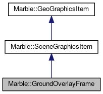
Inheritance graph
[legend]

Public Types

enum  MovedRegion {
  NorthWest, SouthWest, SouthEast, NorthEast,
  Polygon
}
 
- Public Types inherited from Marble::GeoGraphicsItem
enum  GeoGraphicsItemFlag { NoOptions = 0x0, ItemIsMovable = 0x1, ItemIsSelectable = 0x2, ItemIsVisible = 0x4 }
 

Public Member Functions

 GroundOverlayFrame (GeoDataPlacemark *placemark, GeoDataGroundOverlay *overlay, TextureLayer *textureLayer)
 
virtual const char * graphicType () const
 
void update ()
 
- Public Member Functions inherited from Marble::SceneGraphicsItem
 SceneGraphicsItem (GeoDataPlacemark *placemark)
 
 ~SceneGraphicsItem ()
 
const GeoDataPlacemark * placemark () const
 
GeoDataPlacemark * placemark ()
 
QList< QRegion > regions () const
 
bool sceneEvent (QEvent *event)
 
void setRegions (const QList< QRegion > &regions)
 
- Public Member Functions inherited from Marble::GeoGraphicsItem
 GeoGraphicsItem (const GeoDataFeature *feature)
 
virtual ~GeoGraphicsItem ()
 
const GeoDataFeature * feature () const
 
GeoGraphicsItemFlags flags () const
 
virtual const GeoDataLatLonAltBox & latLonAltBox () const
 
int minZoomLevel () const
 
void setFlag (GeoGraphicsItemFlag flag, bool enabled=true)
 
void setFlags (GeoGraphicsItemFlags flags)
 
void setLatLonAltBox (const GeoDataLatLonAltBox &latLonAltBox)
 
void setMinZoomLevel (int zoomLevel)
 
void setStyle (const GeoDataStyle *style)
 
void setVisible (bool visible)
 
void setZValue (qreal z)
 
const GeoDataStyle * style () const
 
bool visible () const
 
qreal zValue () const
 

Additional Inherited Members

- Protected Attributes inherited from Marble::GeoGraphicsItem
GeoGraphicsItemPrivate *const d
 

Detailed Description

Definition at line 21 of file GroundOverlayFrame.h.

Member Enumeration Documentation

enum Marble::GroundOverlayFrame::MovedRegion
Enumerator
NorthWest 
SouthWest 
SouthEast 
NorthEast 
Polygon 

Definition at line 26 of file GroundOverlayFrame.h.

Constructor & Destructor Documentation

Marble::GroundOverlayFrame::GroundOverlayFrame ( GeoDataPlacemark *  placemark,
GeoDataGroundOverlay *  overlay,
TextureLayer *  textureLayer 
)

Definition at line 23 of file GroundOverlayFrame.cpp.

Member Function Documentation

const char * Marble::GroundOverlayFrame::graphicType ( ) const
virtual

Provides information for downcasting a SceneGraphicsItem.

Implements Marble::SceneGraphicsItem.

Definition at line 191 of file GroundOverlayFrame.cpp.

void Marble::GroundOverlayFrame::update ( )

Definition at line 138 of file GroundOverlayFrame.cpp.


The documentation for this class was generated from the following files:
  • GroundOverlayFrame.h
  • GroundOverlayFrame.cpp
This file is part of the KDE documentation.
Documentation copyright © 1996-2020 The KDE developers.
Generated on Mon Jun 22 2020 13:13:45 by doxygen 1.8.7 written by Dimitri van Heesch, © 1997-2006

KDE's Doxygen guidelines are available online.

marble

Skip menu "marble"
  • Main Page
  • Namespace List
  • Namespace Members
  • Alphabetical List
  • Class List
  • Class Hierarchy
  • Class Members
  • File List
  • File Members
  • Related Pages

kdeedu API Reference

Skip menu "kdeedu API Reference"
  • Analitza
  •     lib
  • kalgebra
  • kalzium
  •   libscience
  • kanagram
  • kig
  •   lib
  • klettres
  • marble
  • parley
  • rocs
  •   App
  •   RocsCore
  •   VisualEditor
  •   stepcore

Search


Report problems with this website to our bug tracking system.
Contact the specific authors with questions and comments about the page contents.

KDE® and the K Desktop Environment® logo are registered trademarks of KDE e.V. | Legal