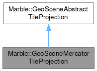
Marble::GeoSceneMercatorTileProjection
#include <GeoSceneMercatorTileProjection.h>

Public Member Functions | |
| GeoSceneMercatorTileProjection () | |
| GeoDataLatLonBox | geoCoordinates (const TileId &tileId) const |
| GeoDataLatLonBox | geoCoordinates (int zoomLevel, int x, int y) const override |
| QRect | tileIndexes (const GeoDataLatLonBox &latLonBox, int zoomLevel) const override |
| GeoSceneAbstractTileProjection::Type | type () const override |
 Public Member Functions inherited from Marble::GeoSceneAbstractTileProjection Public Member Functions inherited from Marble::GeoSceneAbstractTileProjection | |
| GeoSceneAbstractTileProjection () | |
| GeoDataLatLonBox | geoCoordinates (const TileId &tileId) const |
| int | levelZeroColumns () const |
| int | levelZeroRows () const |
| void | setLevelZeroColumns (int levelZeroColumns) |
| void | setLevelZeroRows (int levelZeroRows) |
Additional Inherited Members | |
 Public Types inherited from Marble::GeoSceneAbstractTileProjection Public Types inherited from Marble::GeoSceneAbstractTileProjection | |
| enum | Type { Equirectangular , Mercator } |
Detailed Description
Converts the x and y indices of tiles to and from geo coordinates.
For tiles of maps in Mercator projection.
Tiles do have the same width and the same height per zoomlevel. The number of tiles per dimension is twice that of the previous lower zoomlevel. The indexing is done in x dimension eastwards, with the first tiles beginning at -180 degree and an x value of 0 and the last tiles ending at +180 degree, in y dimension southwards with the first tiles beginning at +85.05113 degree and a y value of 0 and the last tiles ending at -85.05113 degree.
NOTE: The method tileIndexes() handles any latitude value >= +85.0 degree as exactly +85.0 degree and any latitude value <= -85.0 as exactly -85.0 degree. So for higher zoomlevels the outermost tiles will be masked by that and not included in any results.
Definition at line 30 of file GeoSceneMercatorTileProjection.h.
Constructor & Destructor Documentation
◆ GeoSceneMercatorTileProjection()
|
default |
Construct a new GeoSceneMercatorTileProjection.
Member Function Documentation
◆ geoCoordinates() [1/2]
| GeoDataLatLonBox Marble::GeoSceneAbstractTileProjection::geoCoordinates | ( | const TileId & | tileId | ) | const |
Get the boundary geo coordinates corresponding to a tile.
If tildId has values out-of-bounds, the behaviour is undefined.
- Parameters
-
tileId the id of the tile
- Returns
- geographic bounding box covered by the given tile
Definition at line 104 of file GeoSceneAbstractTileProjection.cpp.
◆ geoCoordinates() [2/2]
|
overridevirtual |
Implements Marble::GeoSceneAbstractTileProjection.
Definition at line 120 of file GeoSceneMercatorTileProjection.cpp.
◆ tileIndexes()
|
overridevirtual |
Implements Marble::GeoSceneAbstractTileProjection.
Definition at line 105 of file GeoSceneMercatorTileProjection.cpp.
◆ type()
|
overridevirtual |
Implements Marble::GeoSceneAbstractTileProjection.
Definition at line 19 of file GeoSceneMercatorTileProjection.cpp.
The documentation for this class was generated from the following files:
Documentation copyright © 1996-2025 The KDE developers.
Generated on Fri May 2 2025 12:01:36 by doxygen 1.13.2 written by Dimitri van Heesch, © 1997-2006
KDE's Doxygen guidelines are available online.