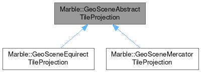
Marble::GeoSceneAbstractTileProjection
#include <GeoSceneAbstractTileProjection.h>

Public Types | |
| enum | Type { Equirectangular , Mercator } |
Public Member Functions | |
| GeoSceneAbstractTileProjection () | |
| GeoDataLatLonBox | geoCoordinates (const TileId &tileId) const |
| virtual GeoDataLatLonBox | geoCoordinates (int zoomLevel, int x, int y) const =0 |
| int | levelZeroColumns () const |
| int | levelZeroRows () const |
| void | setLevelZeroColumns (int levelZeroColumns) |
| void | setLevelZeroRows (int levelZeroRows) |
| virtual QRect | tileIndexes (const GeoDataLatLonBox &latLonBox, int zoomLevel) const =0 |
| virtual GeoSceneAbstractTileProjection::Type | type () const =0 |
Detailed Description
A base class for projections between tile indizes and geo coordinates in Marble.
For map tiling with indizes in x and y dimensions and 1 or multiple zoomlevels. The lowest zoomlevel is 0.
Definition at line 29 of file GeoSceneAbstractTileProjection.h.
Member Enumeration Documentation
◆ Type
| enum Marble::GeoSceneAbstractTileProjection::Type |
Definition at line 32 of file GeoSceneAbstractTileProjection.h.
Constructor & Destructor Documentation
◆ GeoSceneAbstractTileProjection()
| Marble::GeoSceneAbstractTileProjection::GeoSceneAbstractTileProjection | ( | ) |
Construct a new GeoSceneAbstractTileProjection.
Definition at line 31 of file GeoSceneAbstractTileProjection.cpp.
Member Function Documentation
◆ geoCoordinates() [1/2]
| GeoDataLatLonBox Marble::GeoSceneAbstractTileProjection::geoCoordinates | ( | const TileId & | tileId | ) | const |
Get the boundary geo coordinates corresponding to a tile.
If tildId has values out-of-bounds, the behaviour is undefined.
- Parameters
-
tileId the id of the tile
- Returns
- geographic bounding box covered by the given tile
Definition at line 58 of file GeoSceneAbstractTileProjection.cpp.
◆ geoCoordinates() [2/2]
|
pure virtual |
Get the boundary geo coordinates corresponding to a tile.
If x, y or zoomLevel have values out-of-bounds, the behaviour is undefined.
- Parameters
-
zoomLevel the zoomlevel of the tile x the x index of the tile y the y index of the tile
- Returns
- geographic bounding box covered by the given tile
Implemented in Marble::GeoSceneEquirectTileProjection, and Marble::GeoSceneMercatorTileProjection.
◆ levelZeroColumns()
| int Marble::GeoSceneAbstractTileProjection::levelZeroColumns | ( | ) | const |
- Returns
- the number of tiles on level 0 in x dimension
Definition at line 38 of file GeoSceneAbstractTileProjection.cpp.
◆ levelZeroRows()
| int Marble::GeoSceneAbstractTileProjection::levelZeroRows | ( | ) | const |
- Returns
- the number of tiles on level 0 in y dimension
Definition at line 48 of file GeoSceneAbstractTileProjection.cpp.
◆ setLevelZeroColumns()
| void Marble::GeoSceneAbstractTileProjection::setLevelZeroColumns | ( | int | levelZeroColumns | ) |
Sets the number of tiles on level 0 in x dimension.
- Parameters
-
levelZeroColumns new number of tiles on level 0 in x dimension
Default value of the levelZeroColumns property is 1.
Definition at line 43 of file GeoSceneAbstractTileProjection.cpp.
◆ setLevelZeroRows()
| void Marble::GeoSceneAbstractTileProjection::setLevelZeroRows | ( | int | levelZeroRows | ) |
Sets the number of tiles on level 0 in y dimension.
- Parameters
-
levelZeroRows new number of tiles on level 0 in y dimension
Default value of the levelZeroRows property is 1.
Definition at line 53 of file GeoSceneAbstractTileProjection.cpp.
◆ tileIndexes()
|
pure virtual |
Get the tile indexes which cover the given geographical box.
If latLonBox or zoomLevel have values out-of-bounds, the behaviour is undefined.
- Parameters
-
latLonBox the geo coordinates of the requested tiles zoomLevel the zoomlevel of the requested tiles
- Returns
- range of tile indexes covering given geographical box at given zoom level
Implemented in Marble::GeoSceneEquirectTileProjection, and Marble::GeoSceneMercatorTileProjection.
◆ type()
|
pure virtual |
Implemented in Marble::GeoSceneEquirectTileProjection, and Marble::GeoSceneMercatorTileProjection.
The documentation for this class was generated from the following files:
Documentation copyright © 1996-2025 The KDE developers.
Generated on Fri May 2 2025 12:01:36 by doxygen 1.13.2 written by Dimitri van Heesch, © 1997-2006
KDE's Doxygen guidelines are available online.